Thursday, June 29,2017. Original ride lost a rider so going to do this one solo. Temps in 60s, 20% chance for rain, dressed for the ride so let's get it on. At 8:00 a.m. I pushed Redbug out of the garage and headed off from Seymour south bound on US411. Lots of history in this country, early history dating back to the Revolutionary War. Maybe we can pick out a few things to see along the way. I'm primarily riding to let the mind clear and check out my new seat cover recently installed.
Love this big red barn with its silo. It was a dairy farm at one time. It is located south of Seymour toward Maryville on US411.
Heading south out of Maryville, TN. A nice rather small city of 27,000+ people and the home of Maryville College. Here we see people in a hurry and bustling to get to work while I am in no real hurry and have no intention of going to work.

US 411 is a pretty straight shot south. It's not loaded with sweeping curves but does have some nice rolling hills that take you through some beautiful farming country. It runs parallel to the Smoky Mountains.

Vonore is the next town we will pass through and I do mean pass through. Some of these towns actually may sit a little off the main highway but many of them have the highway as their main street.
We keep rolling up and down the hills passing through Madisonville, Englewood, Williamsburg,
Englewood, Tennessee - Wikipedia
Williamsburg, TN - Williamsburg, Tennessee Map & Directions ...
and finally enter the city of Etowah, TN. Here I stopped in at the local Hardee's about 9:30 a.m. to have a breakfast sandwich and coffee. I noticed a gentleman looking at a small book and working with a pencil. He wore a Vietnam Veteran cap so when I finished eating I walked over and introduced myself. He was doing pencil drawings of a bird from a picture in a bird book. He sails them at the local Community Senior Citizens

facility for $2 each. He also teaches art there. Quite a unique fellow and very interesting. It's nice to slow down and smell the roses sometimes which allows you to discover some interesting people, places and things.
Etowah, Tennessee - Wikipedia

After the breakfast stop we crawled on Redbug and continued down US 411 going through Delano and Benton.
Delano, Tennessee - Wikipedia
Benton has a great firearms dealer right on the highway.
Benton, Tennessee - Wikipedia
If you've ever come into Tennessee from the south you will recognize this sign immediately after your first trip. They are painted on the tops of barns, the sides of buildings, on posts along the highway, etc. This is the first one like this that I have seen. Kids love this place as well as adults. If you're eyes are failing you it says "See Rock City".
It looks as if my 20% may catch up to me. But then if it does, just pull over some place and put on the foul weather gear. Or find a coffee pot and hang out until it blows over.
After Benton we get to Ocoee, the junction of US 64 and US 411. There we hang a left heading east.
The Ocoee River was used for the Kayaking portion of the Olympics that was held in Atlanta, GA.
We will amble along the Ocoee River which has a huge backed up lake for a TVA hydro generating station. In fact, we will see several of them along this route and some are pump stations, meaning they pump water up to the top of the hill to a reservoir during the night and let it run back through the generator during the day.
This was a field trip from a summer camp or school as there were dozens of kids being herded by adults here along the river.
Rolling along the Ocoee River. This is a very scenic route and during the summer, like now, it is pretty busy with large buses hauling inflatable rafts and people. They take them up the river, drop them off at a certain point and then pick them up, or what's left of them, at a point down river. It's called having fun.
It's really a beautiful river and today there were just tiny ripples on the water.
Riding US 64 is nice. Some sweeper curves, a few tight ones and occasionally views of the Ocoee River.
The River in places looks as if it is standing still but a bit farther you see it's rush to get somewhere.

Then you start to see the rafters. Sometimes a single raft and sometimes a cluster of them. You could tell they were color grouped by rafting companies, some yellow, some blue, some red, etc.
In places the flow is tumbling over huge boulders in the river, unseen by the visiting vacationers as they try to remember the instructions given before they entered the water.
At this point in the river a lock is in place and the smooth waters above the drop-off are mirror smooth, then comes the drop-off and away you go.
I pulled into this particular parking area which was full of young people writing one item off their bucket list. This particular spot had a sign that reads "Handicapped rafters only". I don't know if they were handicapped or not as they all looked physically okay as their instructor talked them through his signals and what they were to do, etc.
More getting ready just around the bend from the previous picture. It was kind of funny seeing a person inside a raft sitting on dry land making the motions of paddling and steering. I had a little chuckle on that one.
You can see the lock across the river.
A suspended bridge was the way to get to the lock. There were some signs attached to the bridge. I couldn't read what they were but I believe one of them read "Did you kiss your Mommy this morning" because right after you go under that bridge you make the 4' drop-off.
Or maybe it was the red team against the blue time but then you also had a yellow team. I guess which ever group got to the lower pick-up point was the winner. At least they survived.
And with a nice breeze blowing I'm sure it didn't help with the maneuvering of the rafts and current of the river.
A bit farther this is the condition of the river. Some probably wouldn't go rafting if they knew the bottom of the river they were going down actually looked like this.
So the trip goes on and I can again see the mountains far off in the distance.
US 64/74 will take us through Ducktown, TN and the Copper Hill area. A nice little museum here depicting that one day there was 18 mine shafts here bringing out copper ore. My first trip through here was in 1960 and the land was really scared from the smelter run-off. Just barren red clay. Totally different today.
Ducktown, Tennessee - Wikipedia

We will also go through the community of Belltown Hill, the last community before you cross into North Carolina.
First place you come to after crossing into NC is Wolf Creek, NC, a small tourist area of hiking, horse riding and fishing. A "I want peace and quiet" place to go.
Our mountain ride will end soon as we enter a valley. Picturesque but with straighter roads and four lanes.
Our travels will take us through Hothouse, which is a spot in the road, and onward to Murphy, NC which is a nice size town.
Hothouse Township, NC - Niche
Murphy, North Carolina - Wikipedia
After Murphy we will go through the unincorporated town of Marble. And speaking of marble, I just happened to notice the marble patiently residing alongside the highway.
Marble, North Carolina - Wikipedia

Following Marble are the towns of Andrews, which is actually north of our route and a bit east and south of our route is Valleytown, NC. I stopped in Andrews to partake of a cup of hot chocolate and a fried Taquito. It was not a Hispanic establishment but I ate it anyway.
Several of the towns in NC had an array of pretty flowers at intersections or overpasses.
 Andrews, North Carolina - Wikipedia
With the rolling hills and the mountains in the distance the direction looked clear of rain and most enjoyable weather to ride.

But then the mountains changed the weather outlook again. Maybe I spoke too soon above.
The corn in this field looked so rich that you could almost hear it growing.
And the clouds seems to be getting heavier and darker. Again, this could just be in my mind and I'm just thinking they are getting that way. Wheels, keep on turning as we have a ways to go.

A pretty flower garden which has signs indicating they are not to be trod on by wheels. Pretty clear to me in which direction I am to go.

Altitude is getting higher as we come to Topton, NC. I spent the night here with my Dad, Mom and Brother in May of 1960, my first trip to the Smoky Mountains while on our way to Indianapolis, Indiana to see the Indy 500 Race. Hasn't seemed to grow much since then considering the amount of time that has lapsed.
Topton, North Carolina - Wikipedia
Love these old style split rail fences. They never seem to go out of style, especially here in the mountains.
Scenic route, lots of trees alongside the river which does cut down on viewing the water.
And ever so often you break out into a clearing to get a good view.
Traffic was very light today making it more interesting to ride.

I came into this little area that seemed to be right out of some Disney movie, little houses all colorful and bright. It was basically a rafting town all of its own.
Lots of rafting businesses along this highway.

Another point of putting in the rafts for the down river trip.
When is a school bus not a school bus? When it has been converted to haul rafts on top and the crew inside on the seats. This one just carried people but most of them have a flat rack on top to carry rafts.

When I stopped at Andrews I talked with some fellow bikers that were headed to the casino in Cherokee. I caught back up with them.
Taking it easy riding to the Harrah's Casino in Cherokee.
This is Bryson City, NC. I turned off of US 64 onto US 19 to go through town. From the facades you can tell this little town is pretty old. It has become, over the years, a little tourist mecca.
Bryson City, North Carolina - Wikipedia
Kudzu. If you stand still for more than 15 minutes between Bryson City and Cherokee, you will feel something starting to crawl over you. It will be a Kudzu vine.
You will cross the Oconaluftee River several times on this trip. Shallow here.
The river is deeper here. Once reason to have a rafting guide that knows how to maneuver through the rocks.
I rode into Cherokee, NC via the back road so that I could stop at
Hardee's and grab a cup of coffee and stretch. This is a very nice road
through these foothills of the mountains.
Cherokee, North Carolina - Wikipedia

After my coffee stop I headed out for the trip across the mountains. I would exchange US 19 for US 441 through the Smoky Mountain National Park to the Gatlinburg side.
A great road to ride with a medium amount of traffic for this time of year. Vacationers are pouring in so there will be a lot of stop and go traffic until the end of August.
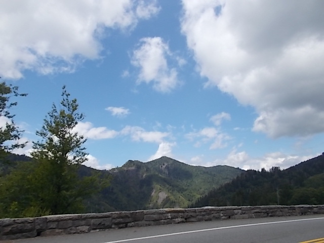
These old mountains just seem to get better with each look.
Can you just imagine the noise made when these started to push up all those millions of years ago. And these are older than the Rockies.

Just tripping it down the
mountain.

Shortly after I get to the Sugarlands Visitor Center I take the Gatlinburg by-pass to make it quicker getting back to Seymour. Gatlinburg is soooo crowded and takes a lot of stop and go to get through it.
The map on the right here is the rout that I took today. Left at 8:00 a.m. and got back to the house, after stopping off to pick up dinner, at 4:30 p.m. A grand day of riding. I met some nice people along the way and had an enjoyable time. Door to door was 262 miles.
My new seatcover made riding better, the rain held off so that I didn't get wet, and a smile is still on my face.
Until the next Valkyrie Adventure, I wish you all a great summer and hope you find some time to enjoy yourselves doing whatever you like to do. Associate with some old friends and maybe make a few new ones in the process. Whatever you do and wherever you go, watch out for your fellow man on 4 wheels or 2. Drive and/or ride safe.


 US 411 is a pretty straight shot south. It's not loaded with sweeping curves but does have some nice rolling hills that take you through some beautiful farming country. It runs parallel to the Smoky Mountains.
  Vonore is the next town we will pass through and I do mean pass through. Some of these towns actually may sit a little off the main highway but many of them have the highway as their main street.

 facility for $2 each. He also teaches art there. Quite a unique fellow and very interesting. It's nice to slow down and smell the roses sometimes which allows you to discover some interesting people, places and things.
 After the breakfast stop we crawled on Redbug and continued down US 411 going through Delano and Benton.


 We will also go through the community of Belltown Hill, the last community before you cross into North Carolina.


 Following Marble are the towns of Andrews, which is actually north of our route and a bit east and south of our route is Valleytown, NC. I stopped in Andrews to partake of a cup of hot chocolate and a fried Taquito. It was not a Hispanic establishment but I ate it anyway.
 Andrews, North Carolina - Wikipedia
 But then the mountains changed the weather outlook again. Maybe I spoke too soon above.

 A pretty flower garden which has signs indicating they are not to be trod on by wheels. Pretty clear to me in which direction I am to go.
  Altitude is getting higher as we come to Topton, NC. I spent the night here with my Dad, Mom and Brother in May of 1960, my first trip to the Smoky Mountains while on our way to Indianapolis, Indiana to see the Indy 500 Race. Hasn't seemed to grow much since then considering the amount of time that has lapsed.


 I came into this little area that seemed to be right out of some Disney movie, little houses all colorful and bright. It was basically a rafting town all of its own.
 Another point of putting in the rafts for the down river trip.
 When I stopped at Andrews I talked with some fellow bikers that were headed to the casino in Cherokee. I caught back up with them.


 After my coffee stop I headed out for the trip across the mountains. I would exchange US 19 for US 441 through the Smoky Mountain National Park to the Gatlinburg side.


 Just tripping it down the
 Shortly after I get to the Sugarlands Visitor Center I take the Gatlinburg by-pass to make it quicker getting back to Seymour. Gatlinburg is soooo crowded and takes a lot of stop and go to get through it.
No comments:
Post a Comment