This is the first long ride of 2016. Thursday, Jan. 7, 2016, 8:30 a.m., 30*. Rolled the 700 out of the garage looking more like the Michelin Tire Man with all the clothes on than a biker. Heated gloves plugged in and turned on to hot hot hot. Pulled out for meet-up with bike friend Paul but needed to top off gas tank before pull out time. Finished and at 8:45 Paul pulled up and we pulled out for Vonore, TN, about an hour's ride south. Traffic was light and we cranked it a bit so that we could meet up with friend Marc at the Food City south of Vonore. Got there a bit early so Paul and I had a quickie breakfast while waiting on Marc. Marc was riding up from Evensville, TN which was about an hour's ride south of Vonore. Now that you have the lay of the land, let's ride.
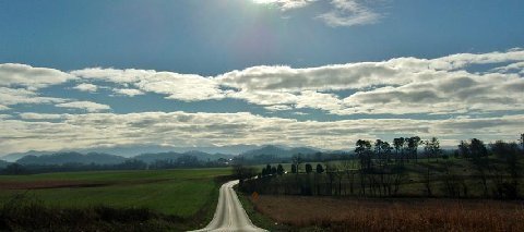
I stole this picture from Paul but the day didn't start out looking exactly like this but isn't this a great looking East TN morning view.
One of my favorite old red barn shots down on U.S.411 south of Seymour.
And this pasture full of Black Angus seemed to have no worries at all, not knowing a carnivorous beast was riding by thinking of burgers, steaks and pot roasts.
Paul getting ready to top off his fuel tank while friend Marc was visiting the store for a cause.

Shortly afterward we three departed for some fun via some different back roads over to Tellico Plaines, TN.
Another glorious day in the land of the free. No mine fields, no rockets flying overhead, nothing but peace and the sound of wind whistling past my helmet and the quiet purr of the engine.
We traveled along easily today as there were few to no vehicles on the road.
Farm animals/pets have heavy hairy coats due to the winter cold weather. And the main part of winter isn't here yet.

Nice rolling hill farm country but mostly into cattle than row crops.
A quick stop in Tellico Plains so Marc could top off his tank and we were back on the road "Cherohala Skyway" which crosses the mountains into NC. This covered bridge is the entrance to a very nice resort lodge just outside of Tellico Plains.
Riding along the Tellico River gives some nice views and scenery.
We were going to run the Cherohala for a short distance and then take a side road over to Bald River Falls which is in the Cherokee National Forest.
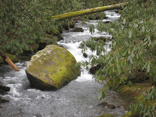
With all of the recent rains the streams and rivers are flowing well.
Each bend gives a different view with some water tumbling over rocks, some small drop-offs or squeezing itself between large boulders.
And then you see the mist in the air. By now it is about 40 degrees. Between my bike and the bridge railing there is ice and the entire area is very slippery.
One of God's great pieces of artwork. This is Bald River Falls. It measures between 80 and 100 ft. high. When the water is really flowing after heavy rains the mist covers the entire bridge with a cloud.
You can imagine this multiplied several times over. You'd need a seeing eye stick to help you get across the bridge.
Paul on the left and Marc on the right. One crazy old man and then just a crazy man but then you only live once right?
After leaving the falls we continued onward along the river to our next adventure which was going to be the North River Road, a stretch 18 miles in length that went through the mountains and would loop back to the Cherohala. Most of this 18 miles was gravel, which in TN is crushed limestone rock. Nothing is round.
Several nice picnic areas along the way and some great views of the water rushing toward the falls.
We are now on the gravel and this is a two way road, it's just all that wide in some places. However, the speed limit is 25 mph so that makes it a bit easier to handle.
A lot of the area is covered with moss so you know it is damp and cool most of the time. And by now you have seen about all of the water pictures you want to see and if so, hit escape.
For there are more coming. To hear that rushing water makes some people want to rush to the bathroom and to others it just lulls them to sleep.

With the recent rains dust wasn't a real problem but there were some chuck holes that could hide a crawfish boiling pot. Thank goodness I was following Marc so when I saw him jerk his Trike around I knew there was at least one big hole ahead.
The stream in the mountains narrowed but the tumbling action continued, just the falls were not as high.
It was very scenic back here and spaced every so often was a camping spot. Camping is allowed in the designated spots and you don't have to worry about seeing your neighbor, especially in the summer. Bring all of your needs for there's no store close by nor any facilities like running water, hot showers, electricity, etc.
That white spot sort of in the center of this picture is not a waterfall. It is frozen run-off from a culvert beneath the roadway. We were going to cross it shortly.
In a bend of the road we decided to take a stretch break, eat a snack bar and gab a bit.

Back on the road again looking out for debris from some strong winds up in the mountains. We noticed a lot of trees snapped off and pushed out of the ground in several places. The winds can get quite high up in these woods.
A nice arch bridge covering this old gravel road. It is part of the Cherohala which meant it wouldn't be too long before we made a turn to get back on hard pavement and run the Cherohala over to the short cut to the Dragon.

My camera battery died so I borrowed this picture from Paul. We noticed the pavement was damp so apparently there was a light rain earlier or it had been very foggy. Determined that it was fog and we soon confirmed our answer.

Now the Cherohala climbs to over 5400 ft. in elevation. The temperature is cold enough here at 1 p.m. to maintain frozen water on the sides of the rocks (that white stuff you see in the bend of the curve).
Which meant the road surface may have just a touch of ice on it. Now put this all together and your cheeks will tighten up just a bit and your throttle hand will go very lightly on the twisting. Fortunately for us it was not ice on the roadway, just moisture from the fog and warm enough to keep it from freezing on the roadway.

Our route to us by the Joyce Kilmer Forest. We stopped for a little while as Marc had not been there or at least had not been there in a long time whichever applies.
It is a very pretty site usually but the high winds and rains had brought down a number of trees. This forest is one of the few virgin forests left in the area. Lots of trails to be hiked and enjoying nature. Here's a couple of nature things enjoying the view from the bridge.
This stream runs beneath the bridge and meanders on down along the roadway that enters the area.

We stopped by Santeetlah Lake which has the Brookside dam. There is a small community here built along the sides of the mountain. Paul and I have been here several times. It is very pretty, quiet and a long way from a Walmart Store.
We followed a rode that took us down to the bottom of the dam thinking that white streak was overflow iced but it wasn't. It was running water. Made an interesting picture anyway.

Now for the rest of the story. Santeetlah Lake drains water through this pictured pipe to a lower level.
That rushing water from the pipe then turns the generator of the Brookside Station power provider to form another lake and a river that allows the water to continue down the mountain. It's not Niagara Falls but it does the trick.
Heading onward toward The Dragon.
After running The Dragon, and with only one vehicle, if my memory is right, on the road besides us, we come to a turn off facing this beautiful old lodge. Now to run along the lake to the Foothills Parkway.
Cherohala Lake is very low on purpose as TVA is getting ready to do some dam inspections/repairs if it will stop raining long enough to draw down the water level. Normally the bottom of the tower legs are just above the water line.
We said goodbye to Marc who headed back to his home while Paul and I hit the Foothills Parkway headed to Walland and a cup of coffee before heading back to our houses. The Smoky Mountains from the Parkway.
And finally a few back roads later we arrive at our start-up point to check the mileage of the trip and Paul's odometer. We both filled up and zeroed out odometers that morning as we usually do but today was for another purpose. Paul recently changed the sprocket size and rear tire of his bike and needed to see how much his odometer and speedometer was off. It came out to read about 9% less mileage and slower that it shows.
Total mileage for me today, door to door, 188. Gas mileage riding the 700, 72.5 mpg. Total amount of fun, too high to calculate. So until the next trip, I hope all of you will get out, even if it's a bit chilly, and enjoy this good earth. And don't forget to tell someone hello. Maybe even that you love them. Be safe.


 Shortly afterward we three departed for some fun via some different back roads over to Tellico Plaines, TN.


 Nice rolling hill farm country but mostly into cattle than row crops.


 With the recent rains dust wasn't a real problem but there were some chuck holes that could hide a crawfish boiling pot. Thank goodness I was following Marc so when I saw him jerk his Trike around I knew there was at least one big hole ahead.


 Back on the road again looking out for debris from some strong winds up in the mountains. We noticed a lot of trees snapped off and pushed out of the ground in several places. The winds can get quite high up in these woods.
 My camera battery died so I borrowed this picture from Paul. We noticed the pavement was damp so apparently there was a light rain earlier or it had been very foggy. Determined that it was fog and we soon confirmed our answer.
 Now the Cherohala climbs to over 5400 ft. in elevation. The temperature is cold enough here at 1 p.m. to maintain frozen water on the sides of the rocks (that white stuff you see in the bend of the curve).
 Our route to us by the Joyce Kilmer Forest. We stopped for a little while as Marc had not been there or at least had not been there in a long time whichever applies.
 This stream runs beneath the bridge and meanders on down along the roadway that enters the area.

 Now for the rest of the story. Santeetlah Lake drains water through this pictured pipe to a lower level.


No comments:
Post a Comment