Crazy? Possibly. But not completely, yet. Wednesday morning, Feb. 11, 2015. Put on layers of clothing, helmet and gloves, all at room temp of 70*. Walked out into the garage, hooked up the gloves (heated), opened the garage door and pushed Sweet Thang out onto the drive way. Time: 8:20 a.m. Temperature: 26*. Crazy check again, nope, not yet but getting closer. I rode down to corner of Boyds Creek Hwy. and Chapman Hwy. (U.S. 441) to Wiegel's, a convenience store/gas station and filled gas tank. Eased over next door to MickyDs to await biker friend Paul who would be riding the White Rat scooter today as the Ninja got sick yesterday.
Just as I was about half way through a cup of coffee in Paul walks. He wasn't going to eat so I quickly finished my cup of coffee, we discussed his weather predictions or lack of, and mounted our trusty steeds. Our destination today was just over the Kentucky/Tennessee line to a place called Blue Heron Mine. It is actually located within the Big South Fork National Park which is much larger than I originally thought. It starts up in Kentucky and extends down into TN with the Cumberland River running through part of it.

The route today looked sort of like this shown but include a bunch of wriggles at the very end on our way back. We ran I-275 and I-75 up to the point of Pioneer, TN where we made a left, after a warm up break, onto TN 63. The cashier couldn't believe we were riding motorcycles. I grabbed a coffee and answered questions from a younger truck driver about the area and the GoPro Camrea.

Knoxville skyline as we were zipping through on the James White Freeway by-pass to catch I-75. Beautiful day, just a tad cold.
Once we were on I-75 we just cruised along for about another 2 hours until we got off at Pioneer, TN.
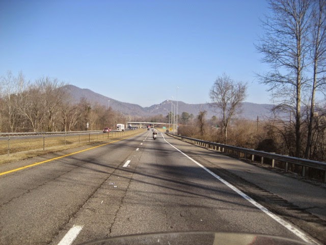
I love I-75 after you leave Knoxville. It is just a very pretty interstate highway with nice long rolling hills and mountains in the distance. You eventually get into the mountains but they're still great to ride through the cuts and see what's in the distance.
Like picture postcards. You round a curve and see this big hill in the skyline. Looks rather drab now but in the spring, summer and fall it will have a lot of color.
At Pioneer, TN we took route 63. We could see the silvery look along the way but once you turned onto 63 you knew it was cold. That hot cup of coffee cooled down really quick on this leg of our trip. That light stuff in the distance is fog ice, or where the clouds settled down over the mountain and into the valley freezing the moisture to the vegetation and rocks. The sides of the roadway were the same color.
You can see a small sample of this right in the center of the picture to the right between the mountains is a white cloud of mist.
We get to see a lot of stuff along the way, like this working diesel locomotive that was probably going to the large wood products mill we had just passed to pick up a few cars of lumber.
The mill in this picture had a large supply of log yet to be sawn into lumber.
Just past the mill was a large area of stacked lumber ready for shipment.
Across from the stacked lumber was a very large area of logs waiting to go to the mill. I'm sure they like to keep a large stockpile due to the ever changing weather that would keep the loggers out of the woods.
Later we were on some small back roads which do not show up on your "most traveled roads for tourists" maps.
However, along a lot of these back roads you see some very pretty buildings like this church. Unusual but then we're in Kentucky.

By now it had warmed up to above freezing. I didn't think my thermometer on my bike would ever get off 30*. Light gray look to the pavement is salt brine residue. A short time later and we entered the Big South Fork River National Park.
On the highway into our destination we pulled over to look at this natural arch. My friend Paul told me to get on top and he'd take a picture. So I did. After I got down he said, "Did you see that crack in the middle?" By then I was off the rock and sure enough, there's a fine hairline crack started on the highway side of the rock. And he was my friend.
Next we rode to the parking lot of an overlook area. Then you had to walk down and up about 600' to the overlook. Beautiful as it overlooks Big South Fork Cumberland River.
After the walk back to the bikes from the overlook we rode a short distance to the Barthell Mine. Roaring Paunch Creek runs alongside the rail line.
The Stearns Coal and Timber Co. was a big outfit back in the early 1900s to 1961. They had approx. 2500 people working for them. The town of Stearns developed due to the mining and timber operations.
This was the Motor House, just one of the buildings on site. It was closed to tourists but since the gate was open
Paul and I extended the privilege of
riding into the facility. We got an opportunity to learn about the place from one of the maintenance people that take care of it during the off season.
One of the houses on site. Some of the houses can be rented during the vacation season. That green on the roof was not the color of the shingles but moss growing there. Apparently stays rather damp and cool in this location.
I don't know whether this is the track for the "A" Train, The Last Train From Denver, The 3:10 From Yuma or just the pony train to the mine.
A steam driven train runs the track during tourist season. It runs from Stearns, KY by this mine, Barthell, to the Blue Heron Mine farther down the line.
Some of the cabins that can be rented.
It was a full mining town with offices for a barber shop, a doctor, a grocery, etc.
The foot bridge crossing the Roaring Paunch Creek.
An old Chevrolet truck, early 30s model. It is one of two trucks left on site. The other is an old KB International.
We left the Barthell Mine and rode on down to the Blue Heron. It was the last mine used, No. 18. In all there were 18 mines within 29 miles of Stearns, KY all owned by the Stearns Mining and Lumber Co. None of the mines were mined out. Each mine had about 50% of the coal mined and they would shut it down and move to another site depending on the cost of mining and the tonnage rate paid for the coal. The coal sold for $1.00 per ton and the miner received $00.10 per ton for digging it out. Good pay back in those days.

A depiction of miners working at the Blue Heron Mine. This mine is along side the Big South Fork Cumberland River. There is a lot of information that can be read on panels beneath a covered roof building. During the summer they lead tours like those of the Barthell Mine.

This bridge crosses the Big South Fork Cumberland River where the actual mine was. They brought the coal over in small cars pulled by mules to a header house where it was dumped into hoppers that filled the gondola cars. The train then delivered the full cars to their destination.
Entering the main mining area you are looking at the header house where the coal is dumped into awaiting rail cars.
Know what these are? Answer: They are called Rail Dogs. These must be at the end of any railroad track if the tracks come to an end. They are to prevent the railcars or train from running off the end of the stopped tracks.
This is a photo of a picture of how the area looked in its heyday.
Looking West at the Big South Fork Cumberland River from the river crossing bridge.
Leaving the Blue Heron Mine area is this beautiful multi-colored stone wall chiseled out the mountain to make the roadway.
We rode back and into Stearns, KY, grabbed another back road and headed back toward home. Just another one of those "don't make a mistake" type roads very common to the Appalachian Mountain Region.
We rode into Williamsburg, KY which is the home of the Cumberland University. The campus is downtown Williamsburg is is very beautiful. All of the buildings are red brick with white columns and dormers, etc. This one had a mural on the side.
Here is another of the large buildings of the campus. I had been by Williamsburg before but never took the time to actually ride or drive into the town.
Another good small highway toward Jellico, TN where we would catch the same interstate that we rode up on. Then back to Knoxville. I left the house at 8:20 a.m. and returned around 5:10 p.m. I quickly hooked up the hose, washed the salt dust off the bike, wiped it down and put her to bed for the next few days as it will be snowing and very cold.
The Big South Fork National Park is now owned by the U.S. Government. It was originally owned by the Stearns Mining and Lumber Co. who sold it back to the government when the mining and lumber business shut down. There are campgrounds, rental cabins, boating, hiking, horseback riding, stables, etc., within this very large parcel of land. Part of it is in Northern TN, the rest in Southern KY. Visit it one day, you're paying for it so enjoy what it has to offer.
A chilly, no a cold start, a warm middle and ending with a door to door mileage of 232 miles. At the end, tired. But what a day of exploring our country while riding with a friend and having a great time. Until the next adventure, you behave yourself but have fun in what you do. Ride/drive safe.


No comments:
Post a Comment