Saturday, 4-12-15, 7:25 a.m., 55 degrees and time to ride. So I pushed Sweet Thang out of the garage and headed off to meet biker friend Paul at the Exxon Station about 4 miles away. Topped off the gas tank, grabbed a cup of coffee and was answering some questions about the Valkyrie when Paul rode up. Here I am again, a half cup coffee left and it's go time. So I dumped the coffee into the trash can, put on the helmet and gloves and away we went. Time, 7:50 and fog. Not bad when I left the house but kept getting heavier as I rode northward. Paul and I pulled out, destination to me unknown but some place up the road about one and a half hours to eat breakfast. Going to be some new roads traveled today.
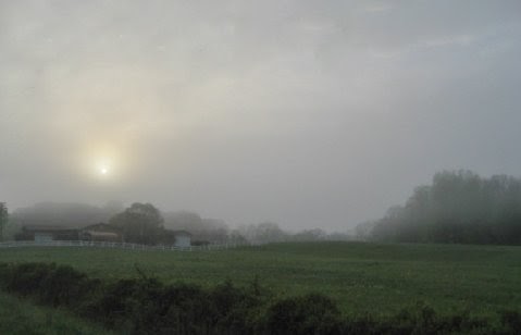
As you can see the sun was trying very hard to burn its way through the mist but not for a while yet. Visibility was about a mile or little less. Not really really bad but just enough to keep you very alert.
Some places it was rather thin and yet just a little way down the road it would get thick again. Shows the temperature changes along the way.
This was not many miles from our meet-up place. You can barely see the oncoming car's headlights. What was really scary was the vehicles that did not have their lights on or people driving with park lights instead of headlights.
I told Paul later that apparently a lot of people had not read the DMV manual on vehicle operation concerning when you're suppose to have your headlights on. So if you don't know, in most states it is 30 minutes prior to sunset until 30 minutes after sunrise and in inclement weather conditions, i.e., fog, rain, smoke, dust, etc.
That small building in the distance is the Seven Islands School House. Long no longer a school and very lonely sitting out in this pasture by itself. Nature is taking its toll on the building. It resembles a church complete with a bell tower. I have photographed it at various periods through the last few years, once with snow on the ground. An era slipping into the past.
Ole Sol was working hard to put some sunshine on us today but struggling to do so.
Finally we start seeing less and less fog. Of course this is a mile by mile thing as later we would cross a river and you couldn't see it, just the bridge we were on.
Taking the back roads as usual, we pulled into Dandridge, TN, home of the TN Scotch-Irish festivities. It is a pretty small town which dates back into the late 1700s.
The buildings look very much like those of New England and around Williamsburg, VA.
It is now protected by a very large earthen dam for Douglas Lake, a TVA hydro-generating facility. I believe Betsy Ross came from this area.
Part of the downtown Dandridge area.
This building is where the annual Scotch-Irish Festival is headquartered. The streets are blocked off and vendors, parades and songs are performed.
Leaving Dandridge you can still see some fog off in the distance but look how beautiful the shrubbery are. In our area the White Dogwoods are starting to lose their flowers and leaves are appearing. The Red and Pink Dogwoods are still well in bloom along with the Flowering Crabapple, Cherry and now comes the Snowball bushes. Big round white flowers that look like snowballs on dark green leaves for a backdrop.
Back into the fog again. This is one of my favorite pictures of the day.

Some well recognized shapes and then some rather ghostly loom off in the distance.
What you're seeing is the concrete rail of a bridge crossing a river and somewhere in that fog is water, trust me, for I've seen it where there was no fog.

As the fog lifts the scenes appear much brighter and more recognizable. The rains and warmer temps have turned most of the dank winter gray to bright spring greens.
Getting to this church reminds me of a saying my father had, I'll get there "if the creek doesn't rise and Devil doesn't care". There were a lot of houses in the same fix. And some of those bridges didn't look none to sturdy to drive across.

The grass is so green that you can almost smell the chlorophyll in it.

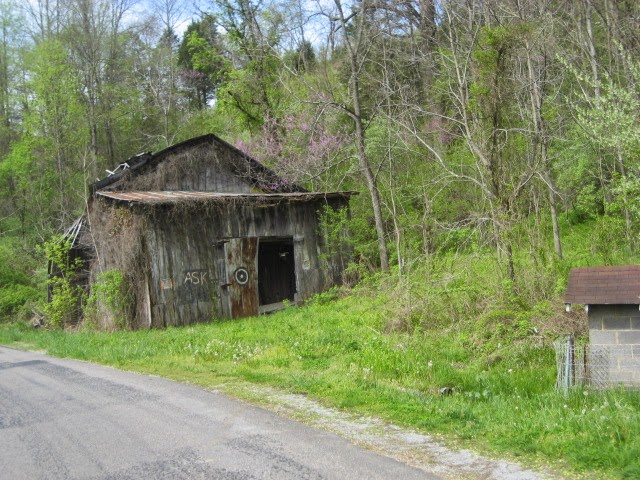
An old barn still in use. Those ripples in the right picture are not terraces made by man but trails made by cattle grazing the hillside.
After the run through the northbound valley we were now back into the mountains and those curvy roads.

You see a lot of natural gray barns, a lot of red and white barns but rarely do you see a blue barn. The farther north we traveled the prettier the Redbud trees looked.

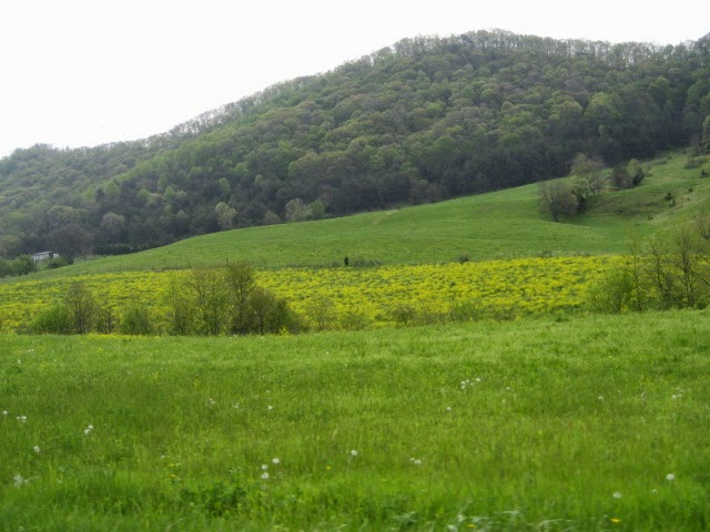
A section of this pasture had some type of wild yellow grass growing. Just a weed but in clumps it was pretty. The house to the right had a bright bronze metal roof. Odd.

We have stopped by this church before on a ride. They apparently on nice days have outside sermons held. The building to the right is another business that over the years failed.
Lots of barn/building quilts, those patterns painted on the sides. And then there are some that have no paint at all and the sides are leaning or gone.
Nice long sweeping curves running through this area with an occasional set of tight curves to keep your concentration level higher.
Indication of bridge engineering, one a foot bridge and one that is for vehicles. I would imagine the vehicle crossing goes under water from time to time.
When riding through some of this country it makes me wonder how people found these places to build and raise families. There's no real close towns and believe me, you won't run down the road in a minute or two to a grocery either. You had better make a very good list of needs before you leave the house.
This was the Mahala Mullins house, moved from its original location to this spot back in the 1990s. The house dates back to the 1700s. The family were known as Mulungeons, or in Portuguese, mixed people. They were decendants of Portuguese sailors and African-Americans originally from South Carolina.

The house had four rooms, two downstairs and two upstairs.
In the back of the house was some old horse drawn farm equipment, a mower, a hay rake and a disk.

Each lower room of the house. Notice the stairs in the right picture for getting to the upper rooms. Better be a small person to walk up those.

The Redbud tree in the back of the shed was a peak bloom. Soon the buds fall off and leaves take their place.

This Presbyterian Church across the road from the Mullins house was built in 1889 and is still in use.
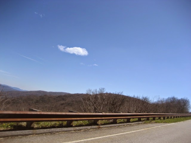
Miles down the road running in the valley along the Blackwater River, we took a moment to stop, stretch, drink a bottle of water and admire the beauty of nature. We were now heading back to the house.


Not many sheep in this part of TN but you do occasionally run across a few. Mountains become the backdrop to this farm along the valley road.

Out of the valley and over the mountains, ride cowboy ride. Then along comes a pasture filled with horses grazing on the fresh green grasses the land had to offer.
Today we stopped again by my favorite motorcycle shop so that I could order a new rear tire and some other parts. Time for a Spring Tune-up. May have to dip into the grocery money this time as I'm nearing 100,000 miles on it and will need a few extra things attended to. After that brief stop, off to the house and take care of some chores. Arrived around 3:00, time to get the mower running and mow the lawn before the rain starts. And I just barely finished as it was already dropping rain as I put up the mower.
The ride today was up and back through two beautiful valleys and lots of farms. The weather was nice, the sun came out, and we made the run safe and sound. Total mileage today, door to door, was 198 miles. And a great time we had. Sad part was that the little Country Market where we had breakfast is on its last financial leg. It will soon be going out of business as they are way to small to be competitive with the larger supermarkets. Great folks and hate to see them shut the doors.
So until the next Valkyrie Adventure, tune up your lives and explore what has been so graciously give to you. Go see what's around the next bend in the road or over the next hill. Life can be good so enjoy it.


 Paul, a.k.a., Scooter Trash, Randy and Sweet Thang on the edge of Cherohala Lake.
 Santeetlah Lake from a distance.