A new friend, Bob, and I made plans to meet up Wednesday, Oct. 8, 2014, morning for a ride. Bob is a retired pilot for the Federal Wildlife and Fish Dept. He rides a CanAm Spyder, a reversed trike. I pulled out of the garage at 7 a.m. to meet him in Pigeon Forge, TN for an 8:00 meet-up. I got there early and decided to have some breakfast before riding. As I finished he walked through the door. After a little chatter we decided where we were going to ride to today, mounted our faithful steeds and headed out. It rained at 5 a.m. and the roads were damp so it was going to be a slower than normal riding speed today. The sky was heavy with clouds.
Leaving Pigeon Forge east bound, Smoky Mtns. in the background.
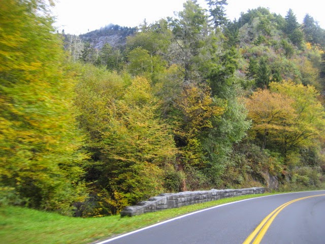
Just entering the Parkway after leaving Pigeon Forge. Large stone wall was placed there due to a landslide about a year ago.
Just before Gatlinburg we took the by-pass that goes around Gatlinburg and makes for a quicker trip to the Park.
About a mile or so out of Gatlinburg is the Sugarlands Visitor Center, gateway to the Smoky Mountain National Park. Nice little museum inside along with a gift shop, free park maps, and lots of information on roads, wildlife, foliage, treking the back country, etc. Not to mention vending machines and restrooms.
Traffic was very light this early in the morning and since it had rained so having to deal with a lot of vehicles wasn't an issue today. This in itself, made the ride more pleasurable. Tourists make a lot of last minute decisions which are not always the best thought-out plan for the day. And with the many turnouts for viewing and taking pictures, it seems someone is always pulling out into the traffic flow without looking at what is about to hit them. I'm saving my money to purchase a large oilfield truck like my Dad use to drive so I can personally punish some of these thoughtless wonders.
Ole Sol was trying to come out from behind those heavy clouds but it was a hard struggle. The air was cool but damp. I had on just the right amount of clothing for the ride. If it was just a bit cooler I would want some heavier clothing or put on my rainsuit to cut the dampness in the air.
The trees, like the rest of us in East Tenn., are becoming confused with the constant weather change. Just as the weather cooled and the leaves started changing color, it has now changed to rain and daytime temps in the low 80s. That will make the leaves turn brown and fall off instead of becoming an artist's paint pallet of color.
Cruising on up the mountain the road runs along the river and every so often crosses it. Thus the river on your left for a mile or so and then same rive is now on your right only to change back later. Nice amount of water running due to the rains. It often rains in the mountains without raining in the lowland or valleys.
The trees are starting to turn nicely and sure hope the change in weather doesn't completely mess them up. The weather also makes it tough to dress for or plan a ride. Those 20%, 30%, 56%, etc., predictions don't mean a thing.
A look at one side of a mountain. Sort of speckled at this time.
Another biker (Bob) about to be swallowed up by the mountain. From the Sugarlands to the top of the mountain at Newfound Gap, you will go through several tunnels and a number of hairpin turns.

At the top of the mountain, Newfound Gap, visitors peering over the side of the mountain looking at the clouds in the valleys below. This is the point where North Carolina meets Tennessee. We took a little break so Bob could stretch his legs. At each stop along the trip we got to know one another a little better.
A burly looking sky casting dark shadows over the landscape but still a beautiful site.
Leaving Newfound Gap behind us we rolled down the mountain side heading toward Cherokee, NC but yet, not the town itself. Just that side of the mountain.
Scenes along the route.
Smokemont is the visitor center on the NC side of the Park. They added a new addition which is glimpsed in the background. Behind the visitor center is an old Appalachian farm and during the Fall, I believe it's the first weekend of Nov., they have people dressed in the era and performing duties common to a farm of that period in time.
Shortly past the Smokemont visitor center we will take a left turn and be on the Blue Ridge Parkway's southern terminus. We will be riding up the Parkway toward Asheville, NC. At this point we didn't know there would be a change to our plan of the day.
Crossing this river puts you on the Blue Ridge Parkway. The gate is open beckoning vehicles to enter for a trip through scenic splendor.
That which changed our plans for the day came at 5,000' above sea level. Fog, a wet misty that hangs in the air and hovers on the ground and sometimes all places between. As I told Bob in flying lingo, it soon became IFR conditions meaning the seeing distance was not very good and you needed the aid of instruments. Our bikes are not equipped with those type instruments so we were just blind.
The speed slowed to about 25 mph, the visibility worsened and believe it or not, there were cars on the road without headlights or lights of any kind. One such vehicle was from the State of Florida which should well be versed in driving in fog or under fog conditions. Makes you want to take a hammer and really put out their lights.
These two ghostly figures were at the point where we stopped to stretch and discuss Plan B. These are restrooms at one of the larger turnouts. No running water here, just new style outhouses.
So, Plan B was to turn around, forget Asheville today and take the turn off to Waynesville, NC, a bustling little tourist town at the bottom of the mountain. This we did, back through the fog but knowing the conditions were going to get better as we went along.
And sure enough, they did. Notice the fog in the top of the trees.

The farther down we went the clearer it got, I think even better than when we went up.
Bob took the turn off to U.S. 276 which would lead us back into Waynesville. He found us an empty parking space right on the main drag of the Historic Downtown section. We were both able to park in a single parking space which made it nice not to have to ride around looking for one. He then told me he was going to take me to one of his favorite places to eat. The restaurant is called "The Sweet Onion." The food was delicious.
After lunch we rode around Lake Junaluska which is between Waynesville and Maggie Valley. I had been by there numerous times but never took the time to ride around the lake. It has a few business but mostly houses built up on the side of the ridge overlooking the lake. Along the lakeside a lot of roses have been planted and Bob said they were beautiful in the summer.
At one location was a very large inn sitting high on a bluff overlooking the lake. Reminds you of the grand old hotels back in the 1920s through the 1940s. Of course I was present until the 1940s and we didn't have any of those where I lived, but I did get to see pictures of them.
I'm glad we took the time to visit this place. It has a lot of spots where you can park and enjoy the scenery, maybe have a picnic, etc. A lot of geese swim about the lake as well as sever white swans.
The foliage around the area is pretty also. Now this is a contrast, green grass, colorful trees and shrubs, with a beautiful blue sky tinged with a white billowy cloud. Sort of sounds like some fancy desert.
After riding around the lake we started back for U.S.276 West, heading for Interstate 40. It was about 3 p.m. by now and about an hour away from the house, give or take a few minutes.
U.S. 276 Westbound. The fire bushes were in full color with the recent cold temps. They are normally green until cold weather starts and the colder it gets the redder they get until they drop their leaves. These are in the median of this 4-lane highway.
Back on I-40 we headed West, back to TN. This stretch of the interstate winds among the mountains and the speed limit is 55 for vehicles other than trucks and the truck speed limit is 50 mph. Trucks are also restricted to the right lane only, if they have three or more axles. This area is also prone to landslides which has the tendency to close down all lanes and you're fortunate if it just closes down two of the four lanes as the detour adds many miles and lots of time to your trip.
The temperature was now up near 80 but you still felt cool riding, especially when you went into the shady side of the mountain. There the temp could drop 5 to 10 degrees and today it was rather gusty. The wind running through the mountain passes makes the highway like a chute or fast lane. And we were bucking the wind which didn't help Sweet Thang's gas mileage one bit.
Just love the ruggedness of the rock and in awe as to how some of the foliage can grow in its crevasses and small amount of soil that gets deposited on it. See, 55 mph. Most of the time.
This highway is heavy with truck traffic as are some other major interstates as the big rigs move across America hauling goods and products.
And finally back into TN where the speed limit increases shortly down the road from here. Then we get to stretch them out a bit running at 70 mph. A few more miles and we will take a run-off to ride the Foothills Parkway over to Cosby, TN.
Tree color along the Foothills Parkway.
More color. As the speed limit is 35 for most of this ride you get an opportunity to see a lot more and at a lesser pace than just glancing.

It sure turned out to be a beautiful day. I never would have guessed it after the heavy clouds of the morning.

The Money Shot. Sweet Thang at 5200 ft. elev. on a foggy morning in the Fall. How sweet she is.
Today we experienced several weather patterns, enjoyed good friendship, ate a delicious lunch, rode some great scenic roads, and traveled 187 miles door to door.
So travel safely and love your family and friends. They're more important than gold or silver. Good riding.


 Destrahan Avenue was once a bustling road of businesses, mostly oil field related. There was a lot of off-shore oil equipment manufactured here, service companies, barge builders, tug boat repair shops, etc., but now there are a lot of vacant yards and building. One business that has expanded is one that builds aluminum boats for excursions and other such uses. They are really beautiful boats which mostly go to the Caribbean area or Bahamas.
 The elevated Westbank Expressway crosses the ICWW, Harvey Canal, just a short distance from the area the aluminum boats are built. It does not open as it is high enough for most all boats using the canal. If not, the boat has to lower it's antennae. Or bend it a little so that it doesn't scrape the bottom of the bridge.


